

Product Details
Emlid Flow: The Mobile App That Makes Land Surveying Feel Like a Walk in the Park—Literally!
Ah, land surveying. The career we all dreamed of as children, right between astronaut and dinosaur. But behold! Emlid Flow is here to make land surveying as easy as pie, and twice as satisfying. So let's get right into it, shall we?
🌟 Key Highlights
- Mobile App for Both iOS & Android: Because we don't discriminate against any thumbs—whether you're an Apple snob or an Android enthusiast.
- Emlid Flow 360 Integration: Like Batman and Robin but in the cloud. Access your projects from anywhere, even from your grandma's basement.
- Custom Code Libraries: More codes than a teenager's diary. Import your own or use our built-in library.
- Multiple Export Formats: CSV, DXF, Shapefile—because options are the spice of life.
- Monthly Subscription Plans: Standard version available Free, Survey version requires an annual susbscription.
Are you tired of juggling various devices and software, only to wind up with data as scrambled as your grandma's eggs? Meet Emlid Flow, your new best friend in the world of land surveying. Compatible with both iOS and Android, this app is the Swiss Army knife of fieldwork.
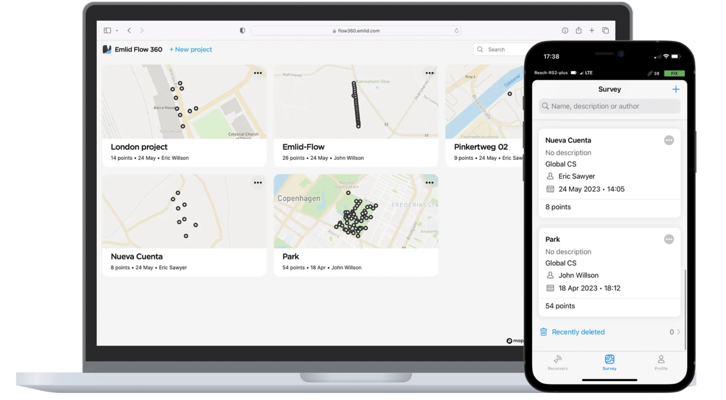
So you've got this fab app. What's next? How about a cloud-based service that holds your hand through the entire process? With Emlid Flow 360, you can store your data, manage survey data and code lists, and generally feel like the surveying god you are. The basic cloud functions are so free, they're practically begging you to use them.
👑 Emlid Flow Standard vs. Survey
🎈 Standard: The "Dipping Your Toes" Free Plan
- Free Basic Cloud Functions: Perfect for the commitment-phobes. Keep your data in sync without even touching your wallet.
- Point Collection: Collect points and write those detailed descriptions. It's like taking notes in class, but you actually care about the subject.
- Stakeout Mode: Get your East-North and straight-to-line distances. It's like having GPS but without the annoying "Recalculating" voice.
- Manage Projects in the Cloud: So you can boss around your data like it's a summer intern.
🚀 Survey: The "I'm Ready for the Big Leagues" Plan
- Everything in Standard: Because we're generous like that.
- Custom Code Libraries: For when you've moved beyond the basics and want to show off your coding prowess.
- Line Collection & Stakeout: Create and collect lines, check their positions, and more. Basically, become the line whisperer.
- Advanced Export Formats: More ways to ship your data out, like a proud parent sending their kid off to college.
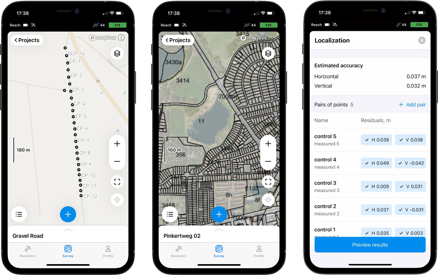
- Background Maps : Upload topographic maps, cadastral plans, and aerial imagery from WMS and WMTS sources or work with a built-in satellite map.
- Localization : Adjust your coordinate system to fit the control points. Find or adjust missing or outdated local coordinate system parameters. Depending on the data provided, Emlid Flow automatically chooses the calibration algorithm that delivers the best accuracy. All residuals are placed on a single screen, so you have the full context while you adjust.
Included
- 1x Annual Emlid Flow Survey Plan License Key sent via email.
Please note, this is only available to customers within the UK
Choosing between Survey and Standard Plans
- What it is: This plan includes all the core functionalities you were used to in ReachView 3. It's completely free to use.
-
Key Features:
- Collect individual points.
- Stake out individual points.
- Work with coordinate systems, geoids, and grid shifts.
- Use custom coordinate systems.
- Export and import data in CSV, DXF, SHP formats.
- Control your Reach receivers.
- Use the built-in NTRIP client for corrections.
- Basic project management and data sync via Emlid Flow 360 cloud platform.
- Who it's for: The Standard plan is perfect if your main tasks involve collecting single points (like placing Ground Control Points - GCPs) or if you primarily need to stream accurate position data from your Reach receiver to other equipment (like tractors, GPRs, or sonars).
2. Emlid Flow - Survey Plan (Paid Subscription)
- What it is: This plan includes everything in the Standard plan, plus advanced features designed for more complex surveying workflows.
-
Key Added Features:
- Collect and Stake Out Lines: Go beyond points to work with linear features. This includes staking out lines using chainage and offset, essential for tasks like road construction.
- Apply Survey Codes: Add feature codes directly in the field as you collect data ("Add codes on the go"), improving efficiency and data organization.
- Satellite Maps: Switch between standard maps and satellite imagery backgrounds directly within the Emlid Flow mobile app for better field context.
- Custom Code Libraries (Emlid Flow 360): Create and manage your own libraries of survey codes within the Emlid Flow 360 cloud platform.
- Satellite Maps (Emlid Flow 360): View satellite imagery within the Emlid Flow 360 cloud platform.
- Benefits: These features are particularly useful for road construction, topographic surveys, cadastral/boundary surveys, as-built surveys, and other detailed mapping tasks. A subscription also includes access to all future feature releases at no extra cost.
- Cost: [Mention the current pricing - e.g., $25/month billed monthly or $240/year billed annually, plus applicable local taxes].
- Who it's for: If your work involves collecting or staking linework, using feature codes in the field, or you need the visual context of satellite maps during survey or data management, the Survey plan provides powerful tools to streamline your projects.
How to Decide:
- If you only need to collect/stake individual points or stream position, the Standard plan is likely sufficient and remains free.
- If you perform more detailed surveys involving linework, require field coding, or benefit from satellite map views, the Survey plan offers valuable advanced capabilities.